
Product Deep-Dive
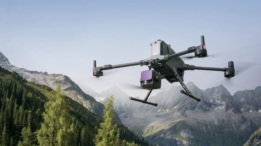
DJI Matrice 400 + Zenmuse L3: Survey-Grade LiDAR in Canada
What survey-grade drone LiDAR actually costs and configures like in Canada — Matrice 400, Zenmuse L3, D-RTK 3, and the field discipline behind DJI's published 3 cm accuracy figure.
Remote Robotic · July 13, 2026 · 14 min read
Specs cited from DJI Enterprise product pages and user manuals (Zenmuse L3 v1.0, Matrice 400 v2.0). Real-world results vary with base-station setup, terrain, and post-processing. Last reviewed: July 2026.

The Number You're Being Sold — and What It Actually Takes
Every LiDAR spec sheet on the market leads with an accuracy figure. For the Zenmuse L3 it's ≤3 cm horizontal and ≤3 cm vertical at 120 m AGL. It's a real number — DJI measured it — but it's a ceiling, not a floor. You hit it when the base station is right, the flight plan is right, the scanning mode is right, and the post-processing is right. Miss any of those, and "survey-grade" quietly becomes "reference-grade."
This piece walks through what the L3 gives you on paper, what the Matrice 400 airframe enables in the field, and what a complete Canadian survey kit actually looks like when you cost it out.
What the Zenmuse L3 Gives You
The L3 is DJI's flagship aerial LiDAR payload — a long-range 1535 nm scanner paired with dual 100 MP RGB mapping cameras and an integrated POS system. Here's how the accuracy, range, and scan-rate numbers stack up.
Accuracy (DJI-measured)
| Metric | Figure | Conditions |
|---|---|---|
| Horizontal accuracy | ≤3 cm | 120 m AGL, RTK fixed, ideal conditions |
| Vertical elevation accuracy | ≤3 cm | 120 m AGL, RTK fixed, ideal conditions |
| Detection range | Up to ~950 m | 80% target reflectivity, atmospheric visibility 23 km |
| Returns per pulse | Up to 16 | Enables ground extraction under multi-layer canopy |
Pulse Rate & Scanning Modes
| Mode | Effective Pulse Rate | Best For |
|---|---|---|
| Non-repetitive scanning | Up to 2,000,000 pts/s | Corridor mapping, forestry, 3D reconstruction — densest coverage per pass |
| Repetitive scanning | Up to 100,000 pts/s (per line) | Tight-tolerance elevation work, clean line spacing, DTM/DSM production |
Imagery
- Dual 100 MP mapping cameras — used both for colourizing the point cloud and for producing standalone orthomosaics on the same flight.
- Mechanical shutter — eliminates rolling shutter distortion that photogrammetry pipelines have to correct for.
Physical
- 1535 nm eye-safer laser wavelength (Class 1)
- IP54 ingress protection
- Operating temperature: -20°C to 50°C

Getting Survey-Grade Results in the Field
The published accuracy numbers assume four things line up on every flight. Miss any one and your deliverable degrades from survey-grade to reconnaissance:
- Centimetre-level GNSS corrections. Either a D-RTK 3 Multifunctional Station set up over a known point, or a Canadian NTRIP subscription (SmartNet, CanNet, provincial CORS). Without corrections, the L3 is a reference sensor, not a survey sensor.
- Correct flight altitude and speed. DJI measures the accuracy figures at 120 m AGL. Fly higher and you gain area at the cost of density; fly lower and you gain density at the cost of area. Match the plan to the deliverable, not to instinct.
- The right scanning mode for the deliverable. Non-repetitive for corridors, canopy, and 3D. Repetitive for tight elevation. Wrong mode, wrong result.
- Proper post-processing. Trajectory smoothing, strip adjustment, and control-point matching in DJI Terra — or an equivalent pipeline. Raw LAS out of the sensor is a starting point, not a deliverable.

Remote Robotic Catalog
D-RTK 3 Multifunctional Station
CAD $2,205
Multi-constellation base station. Centimetre-level RTK corrections in base, relay, or rover modes.

Remote Robotic Catalog
D-RTK 3 Survey Pole & Tripod Kit
CAD $619
Field-ready mounting for the D-RTK 3 — 2 m survey pole plus dual-lock tripod.
When LiDAR Struggles
LiDAR is the right tool for a lot of things. It's not the right tool for everything:
- Very high-reflectance surfaces — fresh asphalt, wet concrete, snow — can starve returns and thin the point cloud.
- Extended baselines from the base station erode RTK fix quality. Keep the D-RTK 3 within reasonable range or set up multiple bases for large sites.
- Photo-realistic 3D deliverables — a colourized point cloud is not a photogrammetric mesh. If the client wants a textured 3D model of a building facade, RGB photogrammetry is still the play.
Why the Airframe Matters
You can't decouple the sensor from the aircraft. A survey-grade payload on the wrong airframe means shorter flights, more battery swaps, and more trajectory noise. The Matrice 400 is DJI's answer to the survey question.
Matrice 400 Key Specifications
| Specification | Value |
|---|---|
| Max takeoff weight | 15.8 kg |
| Max flight time | Up to 59 min (no payload) — real survey missions with L3 typically 40–50 min |
| Max operating altitude | 7,000 m |
| Operating temperature | -20°C to 50°C |
| Ingress protection | IP55 |
| Transmission | O4 Enterprise — up to 40 km with the O4 Ground Station |
| Dual downward gimbals | Supported (via Dual Gimbal Connector) |
For the transmission story specifically, see our deep dive on the DJI O4 Ground Station — that's what stretches the M400's usable coverage to 40 km on remote corridor work.

The Complete Bill of Materials
A survey-grade Matrice 400 + L3 kit is not just an airframe and a sensor. Here's the catalog build we quote most often:
Remote Robotic Catalog
DJI Matrice 400
Quote
The airframe. 15.8 kg MTOW, 59 min endurance, IP55, O4 transmission.

Remote Robotic Catalog
Zenmuse L3
CAD $22,073
The sensor. 1535 nm long-range LiDAR + dual 100 MP RGB.

Remote Robotic Catalog
DJI TB100 Intelligent Flight Battery
Quote
Standard M400 battery. Plan for at least 2–3 sets per crew per site day.

Remote Robotic Catalog
DJI BS100 Battery Station
CAD $1,675
Field charging hub. 0–100% in ~45 min at 220 V, wheeled for site deployment.

Remote Robotic Catalog
DJI RC Plus 2 Enterprise Enhanced
CAD $1,855
Controller. 7" 1200-nit screen, IP54, O4/SDR/4G hybrid transmission.
Remote Robotic Catalog
D-RTK 3 Multifunctional Station
CAD $2,205
Base station. Non-negotiable for hitting the published accuracy figures.
Processing: DJI Terra, DJI Modify, and Beyond
Raw LAS out of the L3 is a starting point, not a deliverable. The workflow we recommend:
- Trajectory + point-cloud processing in DJI Terra. Terra Standard is enough for most corridor and site work; Flagship adds advanced classification and larger project handling.
- 3D mesh clean-up in DJI Modify when the deliverable is a textured 3D model rather than a classified point cloud.
- Downstream classification in LiDAR360, TerraSolid, ArcGIS Pro, or Global Mapper — the L3's LAS/LAZ export drops straight into any standard geospatial pipeline.

Remote Robotic Catalog
DJI Terra
From CAD $2,325 (1 yr, Standard)
Trajectory processing, point-cloud generation, orthomosaic production.

Remote Robotic Catalog
DJI Modify
CAD $4,365 (permanent, Flagship)
3D mesh editing, cleanup, and classification for polished deliverables.
Canadian Operators: What This Means for Your Program
Survey-grade drone LiDAR isn't gated by Transport Canada certification the way over-people operations are — the Matrice 400 and Zenmuse L3 are both available and legal to operate in Canada today. What gates it is competence: pilot training, base-station discipline, and post-processing skill.
If your team is stepping up from a photogrammetry-only workflow, expect a learning curve on the LiDAR side. If you're stepping up from an M300/M350 RTK with the L1 or L2, the Matrice 400 + L3 gives you longer endurance, longer transmission range, denser point clouds, and better canopy penetration — but the field procedures don't change materially.
Pilots operating a Matrice 400 for Advanced RPAS work need a Transport Canada Advanced pilot certificate. Our RPAS training and ROC support covers both the certificate and the flight-review side.
Why Remote Robotic
We're a Canadian DJI Enterprise dealer with survey deployments across the mining, energy, and public-works sectors. When you buy a Matrice 400 + Zenmuse L3 kit through us, you get:
- Canadian pricing in CAD, with no cross-border shipping or duty surprises.
- Configuration advice — right L3 vs L2 vs photogrammetry decision for the deliverables you actually sell.
- Training and ROC-holder support through Transport Canada Advanced certification and flight review.
- Warranty and Canadian repair — not a US-based RMA path.
Ready to spec a kit? Request a quote with the configuration you're considering — we'll price the full BOM including base station, batteries, controller, and software in one bundled proposal.
Sources
- DJI Enterprise, Zenmuse L3 product page and specifications: enterprise.dji.com/zenmuse-l3
- DJI Enterprise, Matrice 400 product page and specifications: enterprise.dji.com/matrice-400
- Zenmuse L3 User Manual v1.0 (DJI, 2026)
- Matrice 400 User Manual v2.0 (DJI, 2026)
- Transport Canada, Getting a drone pilot certificate: tc.canada.ca
Shop the story
Related products in our catalog
Every product below is stocked and supported by Remote Robotic in Canada.
- DJI Matrice 400
DJI Matrice 400
Flagship enterprise M400 airframe — 59 min flight, 6 kg payload, multi-sensor ready.
View product → - DJI Zenmuse L3
DJI Zenmuse L3
1535 nm long-range LiDAR + dual 100 MP RGB — survey-grade M400 mapping payload.
View product → - DJI Zenmuse P1
DJI Zenmuse P1
45 MP full-frame photogrammetry with global shutter — 3 cm accuracy without GCPs.
View product → - D-RTK 3 Multifunctional Station
D-RTK 3 Multifunctional Station
Cm-level GNSS base / rover / relay — foundation of any M400 survey workflow.
View product → - DJI Terra
DJI Terra
Desktop mission planning + LiDAR / photogrammetry post-processing suite.
View product → - DJI Matrice 4E
DJI Matrice 4E
Compact mapping-first M4 Series with wide + medium-tele + tele cameras and laser rangefinder.
View product →