

Laurent Cataye
Sr. Director of Industrial Sales
Remote Robotic Systems Inc.
Based in Alberta
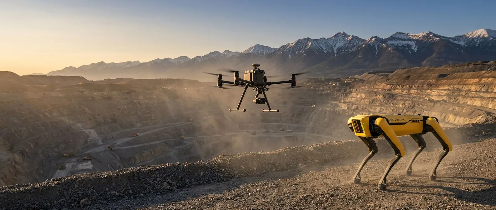
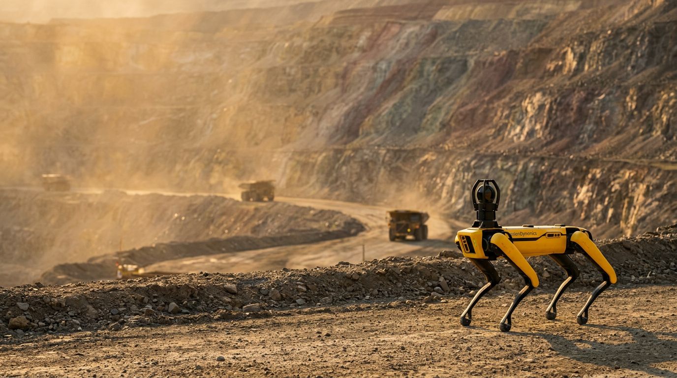
Laurent is not just an expert in technology. He is a pioneer. His work goes beyond deploying drones, robots, and AI; it's about redefining what's possible. He thrives on challenges, engineering solutions where none exist, and turning ambitious visions into reality. Over the past 20 years, across 25 countries, he has helped industrial leaders harness the power of breakthrough innovation to transform operations, enhance safety, and drive new levels of efficiency.
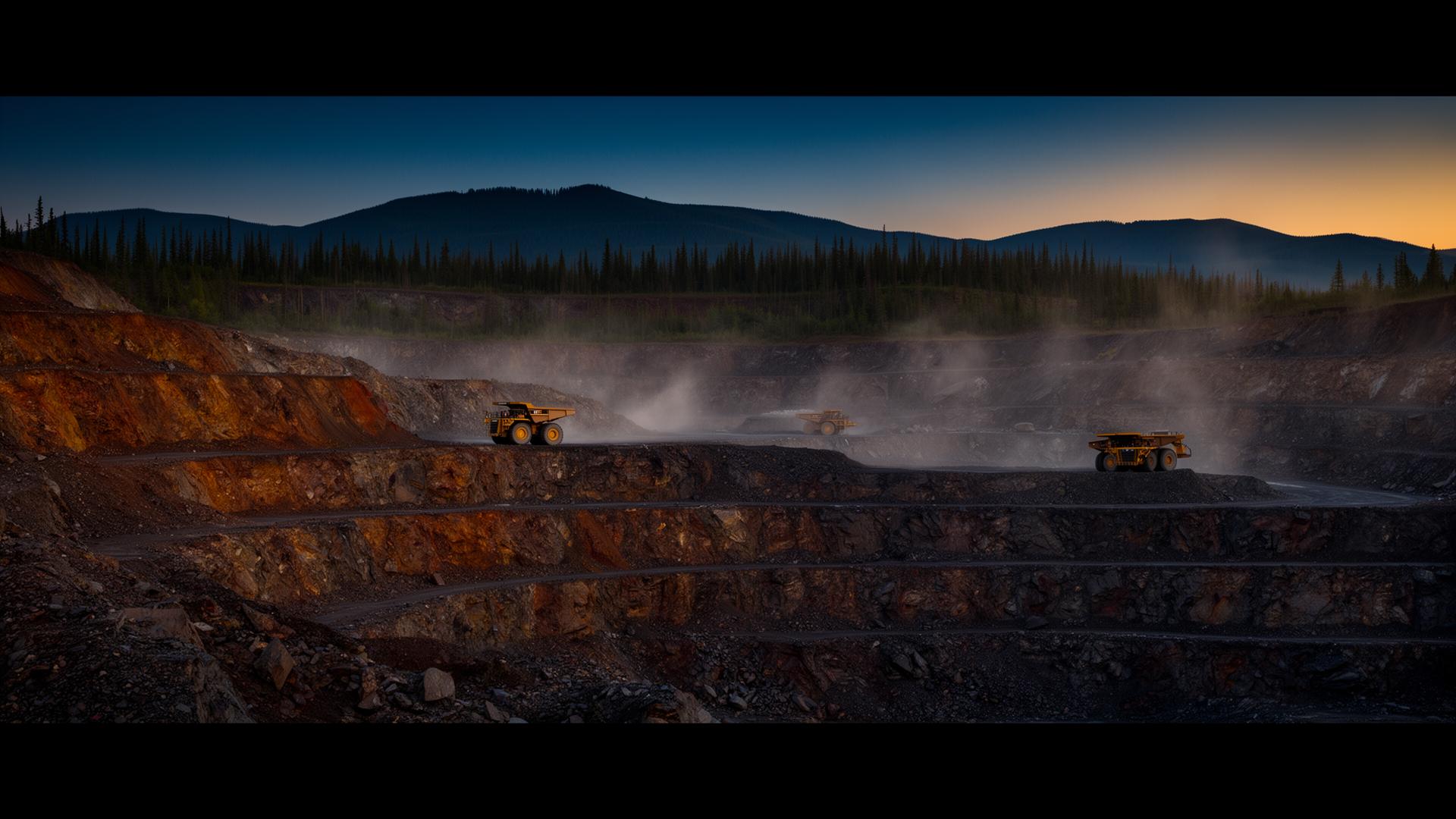
Laurent doesn't wait for perfect conditions, he creates them. Whether working with mining, oil and gas, or power generation companies, he brings a relentless commitment to pushing boundaries, uncovering opportunities, and ensuring clients don't just succeed but lead.
He believes in action over inaction, limitless possibilities over limitations, and results over excuses. If there's a way to make it happen, he will find it. If there isn't, he will create one.
- Based in Alberta
- 25 countries deployed
- 20+ yrs industrial innovation
- Drone, robot & AI pioneer
- Mining, oil & gas, power
- Results-driven


'%3e%3cpath%20d='M-131%20317.3-100.8%20317.3-70.5%20317.3-100.8%20273.5z'%20style='fill:%23f7b400'%20transform='translate(-22,-276.2)'/%3e%3cpath%20d='m%20433.8,30.4%20v%201.5%20h%20-3%20v%209.3%20h%20-1.9%20v%20-9.3%20h%20-3%20v%20-1.5%20z%20m%2010.8,0%20-3.3,8.2%20-3.4,-8.2%20h%20-2.4%20v%2010.8%20h%201.7%20v%20-8.4%20l%203.2,7.9%20h%201.7%20l%203.2,-7.9%20v%208.4%20h%201.9%20V%2030.4%20Z%20M%20-87.3,-46%20V%203.1%20L%20-120,-46%20h%20-23.6%20v%2063.2%20l%2020.9,-30.3%2037.4,54.2%20h%2018.9%20V%20-46%20Z%20m%20346.7,89%20c%2022.2,0%2035.2,-11.6%2035.2,-34.8%200,-23.2%20-13,-34.3%20-34.8,-34.3%20-22.2,0%20-35.2,11.6%20-35.2,34.8%200,23.2%2013,34.3%2034.8,34.3%20M%20270,8.6%20c%200,10.9%20-2.1,18.7%20-10.3,18.7%20-8.5,0%20-10.5,-8%20-10.5,-18.9%200,-10.9%202.1,-18.7%2010.3,-18.7%208.5,0%2010.5,8%2010.5,18.9%20M%201.1,22.8%20H%200.2%20c%200,0%20-11.4,3.2%20-20.2,3.2%20-10.2,0%20-15.5,-4.4%20-15.5,-11.4%20H%205.3%20c%200,-13.2%200,-21.1%20-5.3,-29%20-5.3,-7.9%20-14.1,-11.8%20-26,-11.8%20-22,0%20-33.1,13.6%20-33.1,34.6%200,10.1%202.6,18.9%209.7,25.4%205.6,5.1%2013.4,8.1%2027.1,8.1%2013.2,0%2023.4,-2.8%2023.4,-2.8%20V%2022.8%20Z%20M%20-35.7,1.5%20c%200,-6.6%202.6,-12.3%209.5,-12.3%206.7,0%208.3,5.4%208.3,12.3%20z%20M%206.6,-24.2%2023,41.1%20H%2048%20L%2058.2,1.5%2068.4,41.1%20h%2025%20l%2017.1,-65.4%20H%2090.8%20L%2082.2,17.2%2072,-23.4%20H%2049.4%20L%2039.2,17.2%2030.7,-24.2%20Z%20m%20108.8,0%20V%2041.2%20H%20139%20V%202.7%20c%200,-4.4%200.5,-9.5%208.1,-9.5%203.2,0%205.6,0.9%207,2.8%201.4,1.9%201.4,3.9%201.4,6.3%20v%2038.9%20h%2023.6%20V%202.7%20c%200,-4.4%200.5,-9.5%208.1,-9.5%203.2,0%205.6,0.9%207,2.8%201.4,1.9%201.4,3.9%201.4,6.5%20v%2038.7%20h%2023.6%20V%202%20c%200,-8.1%20-0.2,-14.4%20-3.7,-19.5%20-4.2,-6.3%20-11,-8.1%20-18.2,-8.1%20-12.5,0%20-17.1,5.6%20-19.8,12.7%20-2.1,-7.4%20-7.9,-12.7%20-20.2,-12.7%20-11.6,0%20-17.1,4.9%20-19.5,12.7%20l%20-4.2,-11.4%20h%20-18.2%20z%20m%20185.1,0%20v%2065.4%20h%2023.6%20V%202.7%20c%200,-3.9%200.5,-9.5%208.8,-9.5%203.9,0%206.3,1.2%207.6,3%201.4,2%201.4,4.4%201.4,6.7%20v%2038.2%20h%2023.6%20V%202.9%20c%200,-9%200,-15.1%20-3.7,-20.4%20-3.9,-5.8%20-10.2,-8.1%20-18.4,-8.1%20-11.6,0%20-18.1,4.5%20-20.5,12.7%20l%20-4.2,-11.4%20h%20-18.2%20z%20m%20118.3,48.4%20h%20-0.9%20c%200,0%20-3.5,0.7%20-7.2,0.7%20-3,0%20-5.3,-0.5%20-6.7,-2.3%20-1.4,-1.9%20-1.4,-4.6%20-1.4,-7%20V%20-6.2%20h%2016.2%20v%20-17.1%20h%20-16.2%20v%20-20.4%20l%20-23.2,6%20v%2014.4%20h%20-11.1%20v%2017.1%20h%2011.1%20v%2022.7%20c%200,6%200,12.3%203.5,17.4%203.9,5.8%2010.9,8.1%2021.8,8.1%208.3,0%2014.1,-1.4%2014.1,-1.4%20z'%20style='fill:%23142d7a'/%3e%3c/g%3e%3c/svg%3e)
%20--%3e%3c!DOCTYPE%20svg%20PUBLIC%20'-//W3C//DTD%20SVG%201.0//EN'%20'http://www.w3.org/TR/2001/REC-SVG-20010904/DTD/svg10.dtd'%20[%20%3c!ENTITY%20ns_svg%20'http://www.w3.org/2000/svg'%3e%3c!ENTITY%20ns_xlink%20'http://www.w3.org/1999/xlink'%3e%20]%3e%3csvg%20version='1.0'%20id='svg2402'%20xmlns:svg='http://www.w3.org/2000/svg'%20xmlns='&ns_svg;'%20xmlns:xlink='&ns_xlink;'%20width='200'%20height='200'%20viewBox='205.5%20295.5%20200%20200'%20overflow='visible'%20enable-background='new%20205.5%20295.5%20200%20200'%20xml:space='preserve'%3e%3cg%3e%3cpolygon%20fill='%23FFFFFF'%20points='363.529,370.031%20363.529,420.808%20355.228,420.808%20355.228,380.854%20355.086,380.854%20344.748,420.808%20337.435,420.808%20327.105,380.854%20326.965,380.854%20326.965,420.808%20318.663,420.808%20318.663,370.031%20332.221,370.031%20341.025,403.357%20341.166,403.357%20349.942,370.031%20'/%3e%3cpolygon%20fill='%23FFFFFF'%20points='312.5,412.224%20312.5,420.808%20285.226,420.808%20285.226,370.031%20311.795,370.031%20311.795,378.615%20294.929,378.615%20294.929,390.285%20307.789,390.285%20307.789,398.849%20294.929,398.849%20294.929,412.224%20'/%3e%3crect%20x='205.5'%20y='295.5'%20fill='%23F48412'%20width='200'%20height='200'/%3e%3cpolygon%20fill='%23FFFFFF'%20points='363.529,420.808%20363.529,370.031%20349.942,370.031%20341.166,403.357%20341.025,403.357%20332.221,370.031%20318.663,370.031%20318.663,420.808%20326.965,420.808%20326.965,380.854%20327.105,380.854%20337.435,420.808%20344.748,420.808%20355.086,380.854%20355.228,380.854%20355.228,420.808%20'/%3e%3cpolygon%20fill='%23FFFFFF'%20points='312.5,420.808%20312.5,412.224%20294.929,412.224%20294.929,398.849%20307.789,398.849%20307.789,390.285%20294.929,390.285%20294.929,378.615%20311.795,378.615%20311.795,370.031%20285.226,370.031%20285.226,420.808%20'/%3e%3cpolygon%20fill='%23F48412'%20points='279.799,420.808%20267.574,370.031%20255.127,370.031%20242.539,420.808%20251.889,420.808%20254.632,410.115%20268.058,410.115%20270.519,420.808%20'/%3e%3cpath%20fill='%23FFFFFF'%20d='M267.574,370.031h-12.447l-12.588,50.776h9.351l2.743-10.692h13.426l2.461,10.692h9.28L267.574,370.031z%20M256.388,401.531l4.781-20.536h0.142l4.71,20.536H256.388z'/%3e%3c/g%3e%3c/svg%3e)


%20--%3e%3csvg%20xmlns:svg='http://www.w3.org/2000/svg'%20xmlns='http://www.w3.org/2000/svg'%20version='1.0'%20width='59'%20height='24'%20id='svg2'%3e%3cdefs%20id='defs4'%20/%3e%3cg%20transform='translate(-268.73736,-435.5029)'%20id='layer1'%3e%3cpath%20d='M%20279.85833,441.14687%20L%20279.85833,458.28887%20L%20275.40633,458.28887%20L%20275.40633,441.14687%20L%20269.66933,441.14687%20L%20269.66933,437.37787%20L%20286.20333,437.37787%20L%20284.86033,441.14687%20L%20279.85833,441.14687%20z%20M%20295.52133,457.54087%20C%20294.32333,458.10587%20292.68133,458.72487%20289.81533,458.72487%20C%20284.79733,458.72487%20282.13233,455.15087%20282.13233,450.66487%20C%20282.13233,445.93387%20285.14233,442.42087%20289.52933,442.42087%20C%20294.04533,442.42087%20296.46033,445.61887%20296.46033,450.63487%20C%20296.46033,451.29387%20296.39633,451.73287%20296.39633,451.95187%20L%20286.23933,451.95187%20C%20286.17633,453.07987%20287.11733,455.43187%20290.19033,455.43187%20C%20292.96633,455.43187%20294.71233,454.41087%20295.37333,454.00287%20L%20295.52133,457.54087%20z%20M%20289.62333,445.55687%20C%20287.71233,445.55687%20286.52033,446.99687%20286.20733,448.91287%20L%20292.54233,448.91287%20C%20292.54233,448.06287%20292.22733,445.55687%20289.62333,445.55687%20M%20326.48033,458.28587%20L%20319.58333,449.63187%20L%20326.41633,442.86087%20L%20321.52533,442.86087%20L%20315.91433,448.50387%20L%20315.91433,436.43487%20L%20311.68433,436.43487%20L%20311.68433,458.28587%20L%20315.91433,458.28587%20L%20315.91433,451.04287%20L%20321.46233,458.28587%20L%20326.48033,458.28587%20z%20M%20309.84033,454.29287%20C%20309.55333,454.45887%20308.03333,455.24487%20306.18133,455.24487%20C%20303.35833,455.24487%20301.97833,453.17287%20301.97833,450.47787%20C%20301.97833,448.28387%20303.48333,445.83787%20306.30333,445.83787%20C%20308.06033,445.83787%20309.34533,446.59187%20309.56533,446.74787%20L%20309.80933,443.28187%20C%20308.90833,442.83487%20307.60833,442.41987%20305.92733,442.41987%20C%20301.28833,442.41987%20297.74633,445.89887%20297.74633,450.69687%20C%20297.74633,455.27287%20300.81833,458.72287%20305.64633,458.72287%20C%20307.51033,458.72287%20308.98233,458.23787%20309.98933,457.75387%20L%20309.84033,454.29287%20z'%20id='path2384'%20/%3e%3c/g%3e%3c/svg%3e)